Wednesday, January 30, 2013

Gaibandha District Information


Atlas of Gaibandha District, Bangladesh


Gaibandha District, Bangladesh


Gaibandha district is located in the right bank of Brahmaputra River, the northern part of Bangladesh. Once, the region was a part of Mourza, Paul, Gupta, Kamrupa and many other kingdoms at different times. Anti British movement (1921), Tebhaga Movement (1946), Fakir- Sannayse Revolt, Peasant Movement (1956) etc are the remarkable chapters of the region. According to �The geography of Bangladesh� written by Harun �Or- Rashid, we can guess that once the region was mostly watery area. The previous name of the region was �Bhabanigonj�. During the British East India Company period, Bhabaniganj subdivision under Patiladah Parganah was shifted to 12 Km west in the region King Bhirat called the grazing field named Gaibandha in 1875 due to serious erosion of Brahmaputra river. After the liberation of Bangladesh, Gaibandha subdivision was upgraded into District in 15 February 1984. The Geo position of the district is between 25�30� to 25�39� North latitudesand between 89�12� to 89�42� east longitude.

Bordered By: Gaibandha District is bordered by Rangpur and Kurigram districts to the north, Bogra district to the south, Jamalpur and Kurigram districts and the Brahmaputra River to the east, Rangpur and Dinajpur districts to the west.

Administration: The area of Gaibandha is 2114.77 Sq Km. It is under Rangpur Division. There are 03 Municipalities in Gaibandha named Gobindaganj, Sundarganj and Gaibandha. The number of Upazilla (sub district) in Gaibandha district is 07, named- Gaibandha Sadar, Shadhurampur, Gobindagonj, Sundargonj, Saghata, Fulbari and Polashbari containing 82 Unions, 1064 Mauzas and 1250 Villages. 

Population: The total population of Gaibandha district is 23,79,255 (Male- 11,69,127 and Female- 12,10,128), sex ratio 97:100, population density 1125/Sq Km and annual growth rate is 1.06%.

Literacy: The Literacy Rate of Gaibandha district is 42.80% (Male- 46.30% and Female- 39.50%). School attendance rate is 52.70% for 5 to 24 years age group.

Other Important Data: The postal code of Gaibandha district is 5700 and NWD Code is 0541. Total Parliament seat in Gaibandha is 05. During the liberation war, Gaibandha was under Sector Number 06 & 11. Urbanization rate of the district is 08.85%.

Rivers: Brahammyaputra, Jamuna, Teesta, Kortoa, Katakhali, Ghagot, Manos, Bangali etc. Total rivers length of Gaibandha region is 107.71 Km.

Agro Products: Paddy, Jute, Wheat, Tobacco, Sugarcane, Vegetables etc.

Remarkable Personalities from Gaibandha District

Akhtaruzzaman Ilias (Writer), Abul Hasan Samsuddin (Writer), Samsul Haque (Writer), Khan Bahadur Abdul Mojid, Hamid Uddin Kha, T I M Nurun Nabi Chowdhury (First Muslim ICS), Abu Hossain Sarker (Politician), Shiraj Uddin Ahmed (Deputy speaker of formerly East Pakistan), Shah Abdul Hamid (First Speaker of Ganaparishad), Poet Saker Mahmud, Poet Haris Chandra,  Samsul Hoque, Tulshi Lahiri, Abdul Hafiz, Gobinda Lal Das, Golam Kibria Panu, Abu Hossain Sarker (chief minister of East Pakistan), Tulsi Lahiri, Dr. Md. Shahidul Islam (Ex- DG, BARI), Cook Lonny, Cook Mahfuz etc.

Picture of Gaibandha, Bangladesh

Famous Tourist Attractions in Gaibandha District

Chowdhury Tokiz, Pourashava Bhaban, Bashashi Ghat, Core of the Capital of King Birot, Pirer Hat Mazar, Kantagir Temple, Shrine of Ghager Bazar, Gaibandha Municipality park, Ghaghot River bank etc.


Gazipur District Information


atlas of gazipur

Gazipur District, Bangladesh


Gazipur District is located at just north of capital city of Dhaka, Bangladesh. The previous name of the region is �Joydebpur�. Once, the region was under the deep jungle of Vowal Pargana (Sub- Division). Gazipur district is one of the ancient and historical region with hundreds years old tradition. Sakeswar Monument of emperor Ashok period, Dardia fort of Mourja period, Buddhist Monastery of the king Dhol Samudra reminds us the history of 2500 years ago. The first Bengali dictionary and grammar and the first printed book of prose (1733) was written by Portugal priests in the region. Besides the best Muslin (very thin fabrics) of the country was produced in Titbati village in Kapashia that was very popular throughout the world. During the liberation war, first armed defence was introduced from the region in 19 March. There are 19 KPI, 05 universities, the one and only High- Tech Park of the country and a number of government, semi government and private offices and industries. The large portion of garments industries of the country established in the region. The 2Nd largest Muslims gathering called �Bishaw Istema� held in the district in the bank of the river Turag. The Geo position of Gazipur district is between 23�53� to 24�20�North latitudes and between 90�9� to 90�42� east longitude. The current Gazipur district is formed in 01 March 1984 under Dhaka Division.

Bordered By: Gazipur District is bordered by Kishoreganj and a part of Mymensingh district to the north, Dhaka and Narayanganj districts to the south, Kishoreganj and Narsingdidistricts to the east, Dhaka and Tangail districts to the west.

Administration: The area of current Gazipur district is 1806.36 Sq Km. There is a city corporation; 04 Municipalities in Gazipur named Tongi, Sreepur, Kaliganj and Kaliakuir. The number of Upazilla (sub- district) in Gazipur district is 05, named- Gazipur Sadar, Sreepur, Kalikuir, Kapashia and Kaligonj containing 44 Unions, 715 Mauzas and 1,114 Villages. 

Population: The total population of Gazipur district is 34,03,912 (Male- 17,75,310 and Female- 16,28,602), sex ratio 109:100, population density 1884/Sq Km and annual growth rate is 5.21%.

Literacy: The Literacy Rate of Gazipur district is 62.60% (Male- 66.00% and Female- 58.90%), School attendance rate is 42.50% for 5 to 24 years age group.

Other Important Data: The postal code of Gazipur district is 1700 and NWD Code is 02. Total Parliament seat in Gazipur is 05. During the liberation war, Gazipur was under Sector Number 03. Urbanization rate of the district is 30.48%. Total forest area in the region is 273.42 Sq Km.

Rivers: Lablong, Brahmaputra, Paruli, Turag, Suti, Goali, Banar, Balu, Chelai, Bangshi, Shitalakha etc.

Agro Products: Potato, Paddy, Jute, Oilseed, sugarcane, cotton, bamboo, jack fruit, Papaya etc.

Remarkable Personalities from Gazipur District

Gobinda Chandra Das (Poet), Dr Meghnad Saha (Scientist) Abu Jafor Samsuddin (Journalist and Writer), Tajuddin Ahmed (Politician), Prof. Dr Ekhlash Uddin, Dr Ajit Kumar Saha (Researcher), Mohammad Nurul Islam Vowalratna, Landlord Norendra Narayan Roy Chowdhury (Founder of Baldha Garden, Dhaka) Ahsan Ullah Master (Politician), Mr Kazi Mozammel Hoque (Freedom Fighter and Politician), Shahid (Martyr) Hurmat Ali, Romesh Chandra Mazumdar (Historian), Moyaj Uddin Ahmed (Freedom Fighter) Rajanikant Barman (Footballer) etc.


gazipur, bangladesh


Famous Tourist Attractions in Gazipur District

Nuhash Palli of great legend Humayun Ahmed, Tongi Industrial Area, BRRI, Nakkhatra Bari, Saint Nikolas Church,  National University, Sreefaltali Royal Palace, Vawal Royal Palace, Vawal National Park, Nondon Park, Fantasy Kingdom, Kalinarayana Temple, Jagroto Chaurangi Muktijodha Monument, Machine Tools Factory, Open University, Ansar Academy, Arms Factory, Bangabandhu Sheikh Mujibur Rahman Agricultural University, Dhaka University of Engineering and Technology (DUET) etc.


Gopalganj District Information


atlas of gopalganj

Gopalganj District, Bangladesh


Gopalganj district is located in the south central part of Bangladesh. The district has a rich historical heritage. The region was under Banga State in ancient time. Gopalganj was named after Naba Gopal, the grandson of Rashmoni of Khatra landlord.  The battle of Babur vs Nusrat Shah, Fakir-sannyasi movement, anti British movement, the mass upsurge of 1969 are the remarkable chapters of the region. During the British East India period, Gopalganj was upgraded into a police station by referring Calcutta gazette in 1872 under Madaripur sub division. In 1909, Gopalganj was adorned as a subdivision under Faridpur district. Then Tungipara was included in Gopalganj sadar sub district. Gopalganj city was formed in 1921. After the liberation of Bangladesh, Gopalganj was upgraded into a municipality. Finally Gopalganj was adorned as a district on 1 February 1984 by dividing Faridpur district into five. The Geo position of Gopalganj district is between 22�51� to 23�50' North latitudesand between 89�0� to 90�10� east longitude. Gopalganj is the birth place of the founder of the nation Bangabandhu Sheikh Mujibur Rahaman.


Bordered By: Gopalganj District is bordered by Faridpur district to the north, Bagerhat and Pirojpur districts to the south, Madaripur and Barisal districts to the east and Narail district to the west.

Administration: The area of Gopalganj is 1468.74 Sq Km. It is under Dhaka Division. There are 04 Municipalities in Gopalganj named Gopalgonj Sadar, Mokshudpur, Kotalipara and Tungipara. The number of Upazilla (sub district) in Gopalganj district is 05, named- Gopalgonj Sadar, Mokshudpur, Kotalipara, Tungipara and Kashiani containing 68 Unions, 597 Mauzas and 889 Villages. 

Population: The total population of Gopalganj district is 11,72,415 (Male- 8,77,868 and Female- 5,94,547). Sex ratio is 97:100, Population Density 798/Sq Km and annual growth rate is 0.06%.

Literacy: The Literacy Rate of Gopalganj district is 58.10% (Male- 60.30% and Female- 56.00%), School attendance rate is 57.50% for 5 to 24 years age group.

Other Important Data: The postal code of Gopalganj district is 8100 and NWD Code is 0668. Total Parliament seat in Gopalganj is 03. During the liberation war, Gopalganj was under Sector Number 08. Urbanization rate of the district is 10.98%. Annual rainfall of the district is 2105 mm and average temperature is 25.50� C.
 
Rivers: Modhumoti, Old Kumar, Ghagor, Baghiar, Bilrut, Kaliganga, Tongikhal, Dignar, Bagda, Kushiara, Madhupur, Shayladah, Chanda etc.

Agro Products: Paddy, Jute, Wheat, Oil Seeds, Sugarcane, Jack Fruit, Banana, Palm, Peanuts, Yam, Chilly, Vegetables etc.


Remarkable Personalities from Gopalganj District

Bangabandhu Sheikh Mujibur Rahaman (Founder of Bangladesh), Sheikh Hasina (Politician), Kazi Din Mohammad (Doctor and Educationist) Tarapod Chakroborti (Writer), Noren Biswsas (Literate Personality), Sheikh Fazlul Moni (Politician), Sukanta Vattacharja(Poet) Ramesh Chandra Manumder (Historian), Firoza Begum(Singer), Buddhedeb Vattacharja( Indian Politician) etc 

gopalganj, bangladesh

Famous Tourist Attractions in Gopalganj District

Graveyard of Bangabandhu Sheikh Mujibur Rahaman, Kotali Fort, Orakandi Thagure Bari of Kashiani, Joy Bangla Pond of Gopalganj Sadar, Barni Baor of Gopalganj Sadar, Baganbari of Tungipara (Birds Sanctuary), The Parental Homestead of Poet Sukanta in Kotalipara, Kort Mosque, Chander Bil, Khaner Par Lake, Lal Saplar Bil of Kotalipara, Graveyard of Bangabandhu Sheikh Mujubur Rahaman, Upalpur Landlord House (Currently Tafsil Office), Graveyard of St. Mathuranath, Home of Poet Sukanta Vattacharja, Bahutali Mosque, Uzanir Landlord Palace etc.


Sunday, January 27, 2013

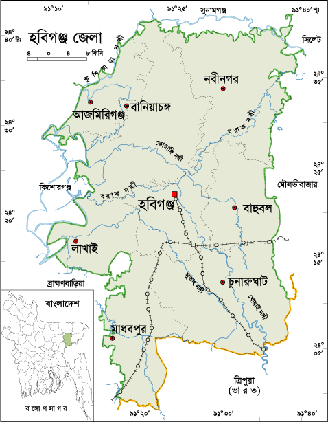
Habiganj District Information


atlas of habiganj


Habiganj District, Bangladesh


Habiganj district is located in the south central part of Surma basin and in the north- eastern part of Bangladesh. The region was named after Sayed Habib Ullah, one of the inheritor of historical Sultanshe Habele. It is a historical town with the memory of saint Sayed Nasir Uddin (R) one of the great followers of Hazrat Shah Jalal (R). Habiganj subdivision was declared in 1867 and established in 1868 during the East India Company period. Through the provincial government of Assam Notification No. 73 on 07 April 1893, Habiganj police station was formed. Habiganj is a historical place where the freedom fighters started their first Gorilla attack against Pakistani army during the liberation war of Bangladesh in 1971. After the liberation of Bangladesh, Habiganj subdivision was upgraded into a district in 01 March 1984. The area of Habiganj is 2636.59 Sq Km. The Geo position of the district is between 23�57� to 24�42� North latitudesand between 91�10� to 91�40� east longitude.

Bordered By: Habiganj District is bordered by Sylhet and Sunamganjdistricts to the north, Tripura (Indian State) to the south, Maulvibazar district to the east, Brahmanbaria and Kishoreganj districts to the west.

Administration: Habiganj district is under Sylhet Division. There are 06 Municipalities in Habiganj named Habigonj Sadar, Madhabpur, Churunaghat, Nobigonj, Shaystagonj and Azmirigonj. The number of Upazilla (sub district) in Habiganj district is 08, named- Habigonj Sadar, Baniachong, Churunaghat, Lakhay, Bahubol, Nabigonj, Azmirigonj and Madhabpur containing 77 Unions, 1120 Mauzas and 2142 Villages. 

Population: The total population of Habiganj district is 20,89,001 (Male- 10,25,591 and Female- 10,63,410), Sex ratio 96:100, Population Density 792/Sq Km and annual growth rate is 1.72%.

Literacy: The Literacy Rate of Habiganj district is 40.50% (Male- 42.20% and Female- 38.90%). School attendance rate is 46.00% for 5 to 24 years age group.

Other Important Data: The postal code of Habiganj district is 3300 and NWD Code is 0831. Total Parliament seat in Habiganj is 04. During the liberation war, Habiganj was under Sector Number 03. Urbanization rate of the district is 11.73%.

Rivers: Borak, Kalni, Kushiara, Khoay, Gopali, Ratna, Karongi, Katati, Sutang etc.

Agro Products: Paddy, Tea, Sugarcane, Betel Leaves, Peanuts, Oilseed etc.

Remarkable Personalities from Habiganj District

Shah Syed Nasiruddin (13th century), Syed Sultan (1550-1648),  Major General Abdur Rob, Bipin Chandra Paul,Mirza Abdul Hai, Dewan Golam Mortaza(Politician), Dewan Farid Gazi (Politician and Journalist), Bipin Chandra Paul, Kali Proshanna (Politician), Dewan Mortuza (Poet), Satis Chandra Roy (Land Lord), Subir Nandi (Singer), Fazle Hasan Abed (Social Worker), Shah A. S. M. Kibria (Politician), Shirajul Hossain Khan, Justice Sayed A. B. Mahmud Hussain etc.

habigangj, bangladesh

Famous Tourist Places in Habiganj District

Ancient Rajbari (1737�38) at Puranbagh,  Bagala Matar Mandir, Baniachong village (The Biggest Village in Asia), Bibir Dargah Mosque,  Bikhangal Akhra,  Dorga-Tila, Mira-Tila and Tangee-Tila,  Foltoli-tila and water fountain, Kalibari,  Kuri-tila, Black-stone and an Ancient Rajbari, Mashulia Akhra, Monument for the freedom-fighters, Teliapara tea garden, Mosque of Uchail, Murarbandar Dargah Sharif, Putijuri Jami Mosque, Ramakrishna Ashram, Rashidpur Tea Garden, Shagor Dighi, Shajeerbazar, Sham-baoul Akhra and Doulotpur Akhra, Tea gardens in the valleys, War of Liberation Mass Grave, Champaboti Mazar, Mysterious Mosque, Ranir Dighi, Tania Para, Liberation War Monument etc. 


Friday, January 25, 2013

Jamalpur District Information


atlas of jamalpur


Jamalpur District, Bangladesh


To get the correct idea about the history of jamalpur district of Bangladesh, we have to remember great saints Hazrat Shah Jamal (R) and Hazrat Shah Kamal (R). They came here to spread Islam and the speech of humanity from Yemen during the period of Mughal emperor Akbar. Jamalpur is named after Hazrat Shah Jamal (R). The previous name of Jamalpur city was �Singhajani�. Fakir Sannyasi Rebellion (1772-1790), Indigo Resistance Movement (1829), famine (1874) are the remarkable chapters of the region.

Jamalpur started its journey as the first Mahakuma (Sub division) of Mymensingh in 1845. The movement of Jamalpur district creation introduced in 1912 after the �Bangavanga�. Mr Lord Karjon decelerated Jamalpur as a district in 1912 but couldn�t implement it due to various obstacle against the East India Company during the time. To set up Jamalpur district headquarters, government acquired 235 acres of land in the municipal area in 1917. In 1938, some renowned educationist raise their hands to set up Jamalpur district and spreaded the movement among the civil people. But even the then British government could not take final decision about the matter. They were in a fix between Jamalput and Tangali, where the district headquarters should be set up. By this time the great flood, communal riots etc made delay the formation of Jamalpur district. So it took 133 years to format Jamalpur district after the formation of Jamalpur sub division.

During the liberation war Jamalpur achieved independence in 10 December. After the newly born independent country, the movement of the formation of Jamalpur district accelerated. In 1975 Bangabandhu Sheakh Mujibur Rahaman committed to form Jamalpur district. Finally 26 December 1978, Jamalpur is adorned as a district. The Geo position of the district is between 24�40� to 25�20� North latitudesand between 89�40� to 90�10� east longitude.

Bordered By: Jamalpur District is bordered by Kurigram and Sherpur districts and Meghalaya (Indian State) to the north, Tangaildistrict to the south, Mymenisigh and Sherpur districts to the east, Bogra district and Jamuna River to the west.

Administration: The area of Jamalpur is 2115.16 Sq Km. It is under Dhaka Division. There are 06 Municipalities in Jamalpur named Melandah, Dewanganj, Jamalpur, Sharishabari, Madarganj and Islampur. The number of Upazilla (sub district) in Jamalpur district is 07, named- Jamalpur Sadar, Islampur, Dewangonj, Sarishabari, Melandaha, Bokshigonj and Madargonj containing 68 Unions, 718 Mauzas and 1361 Villages. 

Population: The population of Jamalpur district is 22,92,674 (Male- 11,28,724 and Female- 11,63,950). Sex ratio is 97:100, Population Density 1084/Sq Km and annual growth rate is 0.83%.

Literacy: The Literacy Rate of Jamalpur district is 38.40% (Male- 41.10% and Female- 35.90%), School attendance rate is 54.70% for 5 to 24 years age group.

Other Important Data: The postal code of Jamalpur district is 2000 and NWD Code is 0981. Total Parliament seat in Jamalpur is 05. During the liberation war, Jamalpur was under Sector Number 11. Urbanization rate of the district is 16.92% and annual average rainfall is 77 mm.

Rivers: Old Brhamoputra, Jamuna, Banar, Jinjira, Chatal, Jhenai etc.

Agro Products: Paddy, Potato, Jute, Tobacco, Yam, Eggplant, Pepper, Mustard, wheat, Vegetables etc.

Remarkable Personalities from Jamalpur District

Khaled Mosharof (Freedom Fighter), Hasan Hafizur Rahaman (Poet), Atiur Rahaman (Politician), Abdullah Al Mamun (Play Personality), Anower Hossain (Actor), Nazrul Islam Babu (Song Writer), Azizul Hoque (Poet) Amzad Hossain (Play maker and Actor), Nazrul Islam Babu (Composer), S M Huda (Play Personality), Hasan Hafizur Rahaman (Historian), Advocate Anwaruzzaman (Language Fighter), Dr Atiur Rahaman (Central Bank Governor), Principal Rais Uddin, Golam Rabbani (Secretary) etc.

jamalpur, bangladesh

Famous Tourist Attractions in Jamalpur District

Jamuna Fertilizer Mills, Lauchapara Paharica Amusement Park, Zhil Bangla Sugar Mill, Shrine of Shah Jamal Shah Kamal, Agricultural Research Institute, Narapara Fort, Lauchapra, Doyamony Temple etc.


Joypurhat District Information


atlas of joypurhat


Joypurhat District, Bangladesh


Joypurhat is small district located in the northern part of Bangladesh. The previous name of the region was �Baghabari Hat� and next it was written �Gopandraganj Hat� in historical documents. During the British East India period, Joypurhat Railway station and post office was established and named Joypurhat to make differ with the name of Joypur located in current India. Then the region got familiarity with the name of Joypurhat with the passing of age. A police station named Joypurhat was established in 1907. Joypurhat was the only subdivision of the formerly Bogra district. After the liberation of Bangladesh, Joypurhat started its journey as a district in 1984. Saotal, Orao, Munda, Mohali, Mohanta, Rajhangshi etc tribes also found in the district and total population of such tribes is about forty seven thousand.

Bordered By: Joypurhat District is bordered by Dinajpur, Gaibandhadistrict and West Bengal (Indian State) to the north, Bogra and Naogaondistrict to the south, Bogra and Gaibandha districts to the east, Naogaon districts and West Bengal to the west.

Administration: The area of Joypurhat is 1012.41 Sq Km. It is under Rajshahi Division. There are 04 Municipalities in Joypurhat named Akkelpur, Kalai, Joypurhat and Pachbibi. The number of Upazilla (sub district) in Joypurhat district is 05, named- Joypurhat, Khetlal, Akkelpur, Kalai and Pachbiby containing 32 Unions, 661 Mauzas and 887 Villages.

Population: The total population of Joypurhat district is 913,768 (Male- 459,284 and Female- 454,484), sex ratio 101:100, Population Density 903/Sq Km and annual growth rate is 0.75%.

Literacy: The Literacy Rate of Joypurhat district is 57.50% (Male- 61.40% and Female- 53.50%). School attendance rate is 56.60% for 5 to 24 years age group. There ere no university, 42 collage (including 3 govt collage), a women cadet collage, 165 secondary high school (including gov. 4), 350 primary school (including gov- 263), a technical school and collage, 13 technical educational institutions, 111 Madrashas, 01 PTI in Joypurhat.

Other Improtant Data: The postal code of Joypurhat district is 5900 and NWD Code is 0571. Total Parliament seat in Joypurhat is 02. During the liberation war, Joypurhat was under Sector Number 07. Urbanization rate of the district is 15.75%. The remarkable Mineral resources of the district are Coal, Limestone etc and average annual average rainfall is 1610 mm.

Rivers: Choto Jamuna, Tulshi Ganga, Haramoti, Chiri, Sree Nadi etc.

Agro Products: Paddy, Sugarcane, Jute, Turmeric, Banana, Potato, Mango, Jack fruit, Pulses, Yam, Betel Leaf, Tobacco, Oil seeds etc.

Remarkable Personalities from Joypurhat District

Bina Pani Sarker, Comored Abdul Kader Chowdhury, Mihir Mukharjee, Ataur Rahaman (Poet), Fatema Tuz Zohara (Singer), Dr Farid Uddin, Dr Abdul Kader Chowdhury, Shahid Mujibur Rahaman, Principal Mohshin Ali Dewan, Abbas Ali Khan, Abdul Alim etc.

joypurhat, bangladesh

Famous Tourist Places in Joypurhat District

Khasmohol Bhaban, Ber Amla Bershibaloy, Pitarer Banglo, Joypurhat Sugar mills, Cement Factory, Pachbibir Mazar, Nandail Lake, Ashranga Lake, Bastob Puri, Graveyard of Mukshid Gazi, Pagla Dewan Mass Graveyard, Gopinathpur Temple, Shisu Uddyan, Nandail Lake, Ashranga Lake, Joypal Rajar Rajbari, Baro Shibmondir, Shrine of Pathorghata, Abul Quashem Field in Sadar, Central Shahid Minar, Joypurhat Cadette College, English Market etc.

Recent Posts

Unordered List